Drone Acronyms
What is MSL (Mean Sea Level) & How Does it Work?
MSL (Mean Sea Level)
Definition
MSL stands for Mean Sea Level. It is the average level of the surface of the sea, used as a standard reference point for measuring altitude and elevation. MSL provides a consistent baseline for determining the height of objects, such as aircraft and drones, above sea level.
How Does Mean Sea Level (MSL) Work?
Mean Sea Level (MSL) is a standard reference used to measure altitude and elevation, representing the average level of the sea’s surface over time. MSL serves as a baseline for measuring the height of geographical features, aircraft altitude, and other vertical distances. Here’s a detailed explanation of how MSL works:
1. Importance
- Baseline Reference: MSL is used as a consistent baseline for measuring altitude, ensuring uniformity in elevation and altitude data across different regions and applications.
- Average Level: MSL represents the average sea level, accounting for tidal variations, weather effects, and seasonal changes over a long period, typically 19 years.
2. System Components
- Tide Gauges: Instruments placed at various coastal locations to measure sea level. These gauges collect data on the water level relative to a fixed point on land.
- Satellite Altimetry: Satellites equipped with radar altimeters measure the distance between the satellite and the ocean surface, providing data on sea level variations globally.
- Geodetic Datums: Reference surfaces used to define MSL. Datums like the World Geodetic System 1984 (WGS 84) provide a consistent framework for measuring elevation and altitude.
3. Data Collection and Processing
- Tide Gauge Data: Tide gauges record sea level at regular intervals, capturing the rise and fall of tides. This data is averaged over a long period to account for short-term fluctuations and establish a mean sea level.
- Satellite Data: Satellites measure sea level across the globe, providing comprehensive data on ocean surface variations. This data is calibrated with tide gauge measurements for accuracy.
- Averaging Process: The collected data is averaged over time to smooth out short-term variations caused by tides, weather, and other factors. This long-term average is used to define MSL.
4. Measurement Process
- Elevation Measurements: Elevation above MSL is determined by measuring the vertical distance from a point on the Earth’s surface to the average sea level. This is done using geodetic instruments like theodolites, GPS, and laser rangefinders.
- Altitude Measurements: In aviation, altimeters measure altitude above MSL by comparing atmospheric pressure to a standard pressure at sea level. Barometric altimeters are calibrated to a standard atmospheric pressure model to provide altitude readings relative to MSL.
5. Applications and Use Cases
- Aviation: Pilots use MSL to determine flight altitude, ensuring safe navigation and separation from terrain and obstacles. Altitudes on aeronautical charts are referenced to MSL.
- Surveying and Mapping: Surveyors use MSL as a reference for measuring and mapping the elevation of land features, creating topographic maps, and conducting geodetic surveys.
- Civil Engineering: Engineers use MSL to design and construct infrastructure, such as bridges, tunnels, and buildings, ensuring accurate elevation measurements for structural integrity and flood risk assessment.
- Climate Studies: Scientists monitor sea level changes relative to MSL to study climate change, sea level rise, and its impact on coastal areas.
6. Advantages and Challenges
- Advantages: MSL provides a consistent and widely recognized reference for measuring altitude and elevation, facilitating accurate and comparable data across various applications.
- Challenges: MSL can vary regionally due to factors like ocean currents, temperature differences, and gravitational anomalies. Continuous monitoring and adjustments are needed to maintain accuracy.
7. Technological Advances
- Advanced Satellite Systems: Modern satellites with high-precision altimeters provide more accurate and comprehensive sea level data, improving the determination of MSL.
- Geodetic Innovations: Improved geodetic models and instruments enhance the accuracy of elevation and altitude measurements relative to MSL.
Understanding how Mean Sea Level (MSL) works highlights its critical role as a standard reference for measuring vertical distances. By averaging sea level data over time and utilizing advanced measurement technologies, MSL provides a reliable baseline for various applications, from aviation and surveying to engineering and climate studies.
Relevance to the Industry
Understanding and using MSL is crucial for accurate altitude measurement and navigation in aviation. It ensures that pilots and drone operators can maintain the correct altitude above sea level, which is critical for safe flight operations, especially when flying over varied terrain and in controlled airspace.
Example in Use
“The drone was programmed to fly at an altitude of 500 feet MSL to ensure it stayed above the terrain and complied with airspace regulations.”
Frequently Asked Questions about MSL (Mean Sea Level)
1. What is MSL and why is it important for drone operations?
Answer: MSL (Mean Sea Level) refers to the average sea level, used as a reference point for measuring altitude. It is important for drone operations because it provides a consistent and standardized baseline for determining altitude. This is crucial for navigation, ensuring safe separation from other aircraft, and complying with airspace regulations.
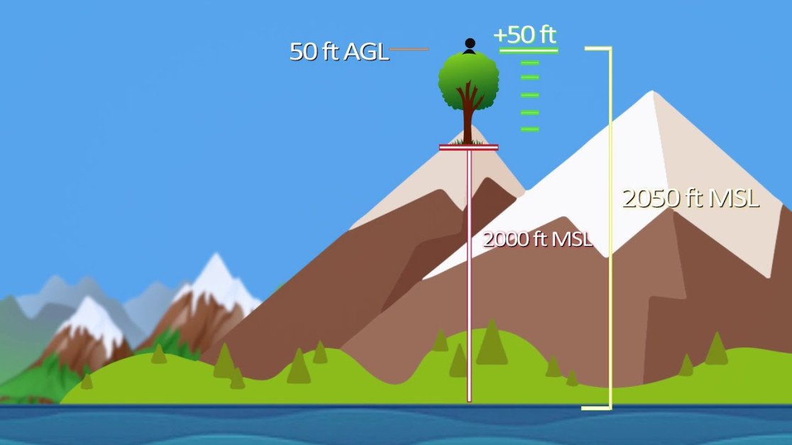
2. How is MSL different from AGL (Above Ground Level)?
Answer: MSL (Mean Sea Level) measures altitude relative to the average sea level, while AGL (Above Ground Level) measures altitude relative to the ground directly beneath the object. MSL is used for navigation and aviation charts where a consistent reference point is needed, whereas AGL is used for precise altitude control relative to the terrain.
3. What are the practical applications of MSL in drone operations?
Answer: Practical applications of MSL in drone operations include:
- Navigation and Flight Planning: Ensuring drones maintain the correct altitude above sea level for safe navigation and compliance with airspace regulations.
- Topographical Mapping: Creating accurate maps that represent the elevation of the terrain relative to sea level.
- Geospatial Analysis: Conducting environmental studies and geological surveys with reference to sea level to understand terrain features and elevations.
- Safety and Compliance: Maintaining appropriate altitude to avoid collisions with other aircraft and adhering to regulatory altitude limits.
For examples of these acronyms visit our Industries page.